

Photographer: Kees van der Aart
Lake Bistreț is a large, shallow floodplain lake a few kilometres north of the Danube, near the villages of Bistreț and Cârna. It anchors the Bistreț–Cârna–Nasta wetland system and is the largest continuous water body in this sector of the Lower Danube floodplain, with an approximate area of 18.8 km². The lake is designated under Natura 2000 and the Ramsar Convention and functions as a dynamic wetland shaped by local hydrology, water management and land use.
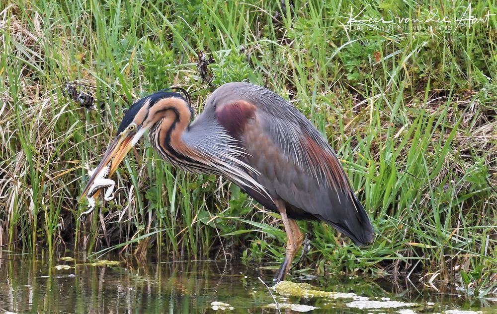
Biodiversity
Open water, reedbeds, marshes and floodplain willow stands form a connected habitat mosaic that extends beyond the formal shoreline. The lake is important year‑round for waterbirds. In migration and winter, it becomes a home to many ducks, geese and swans. In the breeding season, reedbeds and shallow waters give shelter to species such as pygmy cormorant, bittern, little bittern, purple heron, great white egret, little egret and Eurasian spoonbill. Mudflats attract waders (black‑winged stilt, avocet, ruff, wood sandpiper), while floating vegetation supports breeding colonies of common, little, black and whiskered terns. Raptors forage over wetlands and surrounding farmland. Many species rely on habitats outside the formal lake boundary, including downstream marshes and former rice fields.
Tourism and recreation
Bistreț’s wildlife and open landscape make it suitable for nature‑based tourism, though visitor infrastructure is limited and there is no visitor centre yet. Birdwatching, guided nature walks and recreational fishing are established uses. Under the EUROLakes project, WWF‑Romania and local partners like the Dolj County Council, through their nature protection centre, Coridorul Jiului, have mapped a future visitor route and are planning an eco‑trail with interpretive signage to guide access and communicate ecology, conservation status and restoration work. Fishing contributes to local livelihoods but requires clear rules to align with conservation.
Significance for the floodplain
Historically, floodplain lakes and wetlands in the Lower Danube formed a connected, dynamic system. Decades of drainage, embankment and water‑level regulation have reduced connectivity and hydrological variability, simplifying habitats and weakening resilience. Nevertheless, Bistreț remains a key refuge for waterbirds, amphibians and fish, especially in dry periods when alternative wetlands are scarce.
Pressures
The lake faces cumulative pressures from altered hydrology, reduced connectivity and competing water demands, particularly for irrigation. Climate change intensifies droughts and heatwaves. Agricultural runoff adds nutrients and chemicals; in a shallow, slow‑flushing system, this can trigger algal blooms, reduce water clarity and deplete oxygen. Habitat quality is affected by shoreline modification, mechanical disturbance, overgrazing and invasive plants, which also lower the wetland’s capacity to retain nutrients.
Collaboration and restoration
As an EUROLakes demonstration site, Bistreț brings together local authorities, conservation groups, farmers, researchers and communities. Work focuses on reducing nutrient inputs, restoring habitats, improving water‑level management and strengthening cross‑sector dialogue. Lessons from Bistreț will inform restoration of other modified floodplain lakes.
Conservation and responsible use can coexist through zoned, seasonal access and managed visitor routes that minimise disturbance. Properly run nature tourism and recreational fishing can support local development while protecting sensitive habitats and species. By aligning restoration, protection and responsible use, Bistreț shows how a designated floodplain lake can function as a living landscape for biodiversity, ecosystem services and communities.
Contributor: WWF – Romania